
Locus Map 3 Classic
In-app purchases
4.6star
47.2K reviews
100K+
Downloads

Everyone
info


About this app
The third generation of a navigation application for outdoor enthusiasts - hikers, mountain bikers, climbers, trail runners, or geocachers (formerly Locus Map Pro). In full development until 2021, now in maintenance mode.
The application will be retired in the spring of 2026 and completely replaced by its successor, Locus Map 4. Users will receive a 100% discount on Locus Map 4 Premium Silver and a 50% discount on Premium Gold for one year.
Core features:
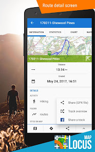
• navigation and route planning, supporting external online and offline routing services
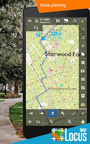
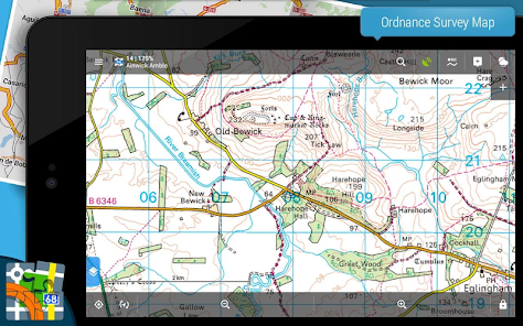
• wide choice of offline and online maps
• advanced map tools - map overlays, offsets, WMS sources support
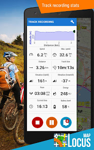
• tools for monitoring sports activities - tracking, audio coach, charts, statistics, support of external sensors (GPS, HRM, cadence...)
• worldwide weather forecast 24/7
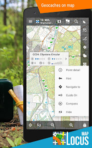
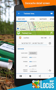
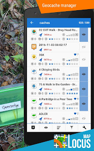
• tools for geocaching • graphic and calculation tools, online/offline logging, support of trackables, Pocket Queries and spoilers
The application uses device administrator permission.
The application will be retired in the spring of 2026 and completely replaced by its successor, Locus Map 4. Users will receive a 100% discount on Locus Map 4 Premium Silver and a 50% discount on Premium Gold for one year.
Core features:
• navigation and route planning, supporting external online and offline routing services
• wide choice of offline and online maps
• advanced map tools - map overlays, offsets, WMS sources support
• tools for monitoring sports activities - tracking, audio coach, charts, statistics, support of external sensors (GPS, HRM, cadence...)
• worldwide weather forecast 24/7
• tools for geocaching • graphic and calculation tools, online/offline logging, support of trackables, Pocket Queries and spoilers
The application uses device administrator permission.
Updated on
Safety starts with understanding how developers collect and share your data. Data privacy and security practices may vary based on your use, region, and age. The developer provided this information and may update it over time.

No data shared with third parties
Learn more about how developers declare sharing

This app may collect these data types
Location, Personal info and 5 others

Data is encrypted in transit

You can request that data be deleted
Ratings and reviews
4.6
44.3K reviews

A Google user
- Flag inappropriate
- Show review history
July 30, 2019
Needed a solid GPS app for work, and this is solid. Easy to use, and still powerful. The free version has most of what MOST people would need. 7/30 update. it keeps getting better! maps render faster since the update. not that it was bad before, but noticable improvement. just got the watch app on S3 frontier, great for a quick glance and to start tracking.
11 people found this review helpful

Lex Python
- Flag inappropriate
- Show review history
August 26, 2020
Updating: not simple to set up but awesome once it works. Definitely kept us going in the right direction on some poorly-maintained wilderness trails. Very deep program - I have a lot to learn to see what else it does. But, once you get past the un-intuitive setup, it's great, rock-solid, feature-rich and easy to use. I spent a good three hours figuring out how to set it up, and would have failed if my friend hadn't helped. It's not THAT hard but you have to download the map you want, then navigate to it on your phone with the app, then enable it in view, which is pretty dense. It would be nice if when you downloaded it, you have the option of "Use This Map?" But, the ability to set pins, use different folders for pins, attach files & photos to the pins, and record your track is pretty solid. It's a deep program, and if you're going to rely on it in the wilderness, sped however long it takes at home to really dial it in and understand it. I still have a lot of learning to do. But, it kept us from taking the wrong trail a dozen times on this past trip, when you're confronted with multiple animal traces, and one is your trail, this app is helpful.
70 people found this review helpful
Asamm Software, s. r. o.
July 3, 2020
Hi Lex,
what offline maps are you trying to download? Locus Map offers many maps from many providers... If you mean LoMaps, download them from menu - Locus Store. For assistance, contact us at https://help.locusmap.eu/ticket/add. Michal, Locus team

Ed Juarbe
- Flag inappropriate
- Show review history
September 19, 2020
In my 10+ years of using smart phones, this is only the 3rd app I've actually purchased, but by far what I consider the best $$ spent on any app so far. Best on-line/off-line mapping app for Android yet! Great user interaction and flexibility if you're into going off grid. I've just scratched the surface, but very happy with purchasing the Pro version.
30 people found this review helpful
What’s new
Various adjustments and fixes as part of routine maintenance.
App support
About the developer
Asamm Software, s.r.o.
locus.map@asamm.com
3129/8 K odpočinku
193 00 Praha
Czechia
+420 775 751 246


